Where Does the South Begin?
The Post had an interesting article last weekend about how the Washington, D.C. region has lost most of its southern identity in recent decades as northerners move in and the federal capital's culture, food, and dialect became more standardized. The article raised the inevitable question: Was D.C. ever a southern city? And if so, where does the South begin?
Most Americans would agree that Richmond is a southern town, but how far north above the capital of the Confederacy does the South extend? Is Fredericksburg a southern town? Annapolis? Harper's Ferry? Louisville?
In some sense it's a ham-handed question, since "the South" has many sub-cultures. Charleston is very different than Dallas; the Great Smokies look nothing like the Delta; and Lexington-style barbecue is sacrilegious in Memphis. But at the same time, most Americans, southern and otherwise, have a psychological concept of the South. The question is the geography of it.
The town of Winchester in the Shenandoah Valley was the base to legendary southerners such as Harry Byrd and Stonewall Jackson, yet it is north of Washington, was settled by Quakers, and has the feel of a Pennsylvania mill town. Not surprisingly, Winchester changed hands 72 times during the Civil War.
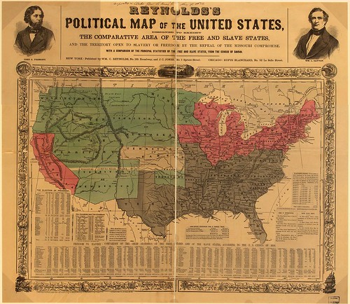
The border is obviously hazy, as anyone familiar with the events of 1861-65 can attest. The five most widely used borders are the Rappahannock River, the Potomac River, the Ohio River, the Mason-Dixon Line, and U.S. Route 40. Each of these can seem equally logical and preposterous depending on what kind of metric you're using. Here are some of the best ways decide:
Surveys and Censuses
The Mason-Dixon Line is the most traditional border between North and South, and to some extent the line made sense in its time. Maryland was a slave state, home to the likes of Frederick Douglas and Harriet Tubman, and Lincoln had to send federal troops into Baltimore to quell secessionist riots -- all suggesting Maryland was a southern state.
The Line endures today and the U.S. Census still lists Maryland and D.C. as part of the South. In fact, the Census even calls Delaware southern, which seems a bit misguided. The concept of the Mason-Dixon Line today is outdated, as few people would describe Baltimore, with its ethnic neighborhoods and industrial tradition, as southern.
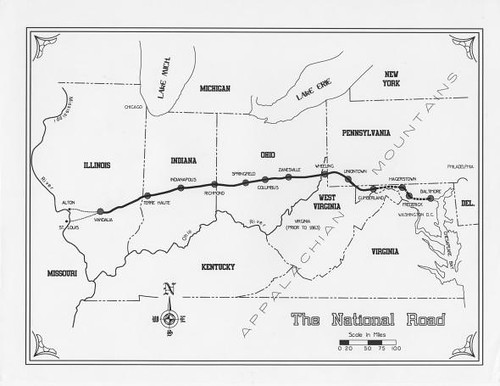
Many historians and sociologists decided long ago that the Mason-Dixon Line was too clumsy and that U.S. Route 40 -- the old National Road -- was a more accurate border. The road extends from Baltimore to Frederick to Cumberland, through Wheeling, across southern Ohio, through Columbus and Indianapolis, across southern Illinois, and out to St. Louis.
In the "Nine Nations of North America," Joel Garreau noted that there are "substantial differences in food, architecture, the layout of towns, and music to either side of that highway." Southern Indiana, he wrote, "is definitely part of Dixie, and has been ever since the Coppherheads (those Northerners who sympathized with the Confederates in the 1860s)."
Rivers
Gen. George McClellan could never cross the swampy Chickahominy River outside Richmond, and so everything south of there is clearly property of Dixie. But a more frequently-used border is the Rappahannock, which is about halfway between Washington and Richmond. Most neighborhoods north of the Rap feel metropolitan while counties south are rural.
The Potomac was also the effective border between the USA and CSA. The Feds' decision to coin the Army of the Potomac was symbolic, as it hinted at the central point. Similarly, the Army of the Ohio suggested that the Ohio River was the western border between North and South, which seems reasonable if you consider Kentucky southern and Ohio northern.
Religion
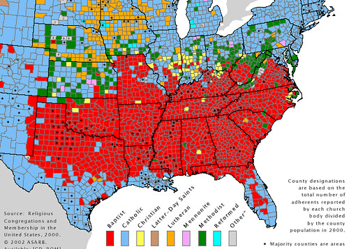
If you look at the Kentucky/Ohio and Kentucky/Indiana borders, you'll also see that the southern state is overwhelmingly Baptist while the northern one is a mix of Catholics, Methodists, and Presbyterians. Not surprisingly, the Baptist counties in southern Illinois supported Stephen A. Douglas (who founded a Baptist seminary) over Lincoln, who was a Presbyterian.
The divide roughly follows the Ohio River, but it cuts across West Virginia, where the southern tier is Baptist and speaks will a drawl and the northern tier is ethnic and cheers for the Steelers. Maryland was a colony founded by Catholics, while Virginia is mostly Baptist with a strong Methodist following in the hills.
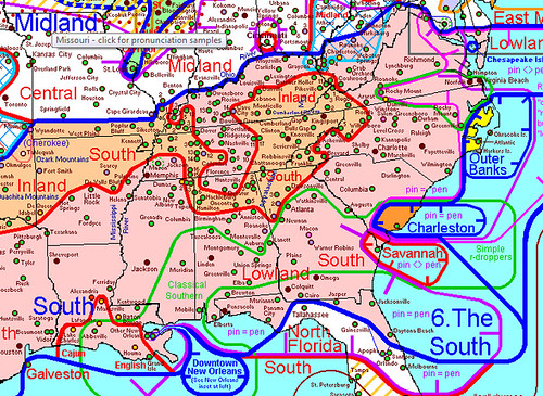
If religion is voluntary, dialect is involuntary. Every American knows what a southern accent sounds like, thanks in no small part to southern caricatures from Boss Hogg to Larry the Cable Guy. The reality of course is that the South consists of a fabric of dialects from the mountain twang of Johnson City to the smooth drawl of Panama City.
What those accents have in common, according to Rick Aschmann's research of regional dialects, is that the South is defined by areas where people pronounce "pen" as "pin." The region he defined as "the South" roughly followed the Baptist/Ohio/Potomac border, with differences between Lowland and Inland and distinct pockets in the old world towns of Charleston, Savannah, and New Orleans.
Food
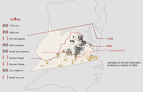
It's tough to think about towns like New Orleans without thinking about food and drink, and really no beverage is more southern than sweet tea. The Post article notes that McDonald's went national with sweet tea in 2008, but prior to that decision, one of the best ways to measure a location's southerness was whether or not Mickey D's served sweet tea.
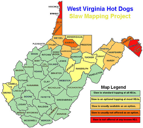
The map below shows the so-called Sweet Tea Line of McDonald's that served the tasty drink in 2004. It's a surprisingly southern border, below Richmond even. The second map is the Slaw Line of West Virginia shows the geographic dispersion of HDJ's (hot dog joints) that serve with slaw and without (h/t Strange Maps). Again, the map is similar to the Baptist Line.
Politics
Lastly, no discussion of the South could be complete without an understanding of its politics. Chuck Todd has said that 2006 was the year that "Virginia seceded from the Confederacy," and sure enough the Old Dominion and neighboring North Carolina voted for Barack Obama in 2008. For this reason, we can't simply look at the recent electoral map.
The best way to measure the South through politics is by examining the "Solid South" of the Wilbur Mills/Sam Rayburn/Willie Talos days in the century following Appamattox. As recently as 1982, Democrats controlled a near monopoly in states like Alabama (105-4 split in House; 35-0 in Senate), Georgia (157-23, 51-5), and South Carolina (107-17, 41-5).
So Where is the Border? It begins with an imaginary line from Cambridge, Md. to Fredericksburg, Va., follows the Rappahannock River up into the Piedmont, across the Baptist Line in West Virginia, along the Ohio River, and along the Baptist Line in southern Illinois.
Roads
Language
Sent from my iPhone
No comments:
Post a Comment